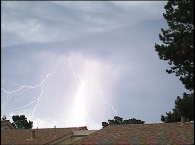
Pebble Beach, California Lightning Strikes
June 22, 2008
No Woman No Cry
“gonna make the fire light
a-log-a-wood burning through the night”
A week ago in Monterey it was 90 degrees Fahrenheit and a lightning storm crossed the Central Coast. This is a photo of the lightning over Pebble Beach area. A storm front with lightning strikes lasting less than 30 minutes only dropped about five minutes of heavy rain here in Monterey. The lightning strikes set off fires along the Central Coast.
The Los Padres National Forest southeast of the town of Big Sur has burned over 30,000 acres in the past week. Some of the oldest existing buildings on the coast ridges around Big Sur burned. The Henry Miller library was almost lost to the fire. Ventana Inn and Post Ranch Inn were evacuated. 20 miles of coast Highway 1 have been closed for the week.
San Jose Mercury news article on Big Sur fires Friday, June 27, 2008
The fire was originally called the “Gallery” fire due to the proximity of the burning forest to an art gallery on Highway 1 and just south of the Nepenthe cliff top restaurant and store. There is a web camera mounted on the deck of Nepenthe’s and the fire area could be seen in the webcam images last Sunday.
Nepenthe Webcam, Big Sur, California
Big Sur Fire Map from KSBW Monterey local TV news
The town of Big Sur is actually open and accessible. Big Sur is hurting at the start of this tourism season, but the air quality is so bad here that I would not recommend anyone coming to this area at the present time. The wind has blown the fires’ smoke over Monterey Bay and all the way up the Salinas and Santa Clara Valleys and it is a week of sore lungs and officially “unhealthy” air.
The “Indians” fire in southern Monterey County on the eastern side of the Los Padres National Forest has been burning for several weeks and so far has scorched over 100 square miles of mountainous land. Together with the Big Sur Basin Complex fires, the Monterey County fires are just about to go over 100,000 acres in burn area. Conditions seem like 1977 when the Los Padres forest fires burned for several months and over 250,000 acres in Monterey County’s mountains and hill country.
California is facing a long hot summer.
A website has been established to coordinate news and resources for those affected by the Big Sur fires:
http://surfire2008.org/index.php
July 3 update: The fire has burned over 55,000 acres. Big Sur was under mandatory evacuation yesterday as the order affects Highway 1 on both sides of road and the road has been closed for a 30 mile stretch. The road looked like the fire line as the flames fanned the ridge above the reporter at Andrew Molera State Park, just north of Big Sur village on last night’s report. The fire is spreading in all directions. Fire still only 3% contained. No more buildings lost yet, but I read the fire is getting closer to Ventana Inn and Resort location. The air has not been too bad in Monterey the past few days with an onshore breeze.
July 8 Update: The fire has now burned over 80,000 acres over the past two weeks. The smoke was attached to the fog yesterday and the smell in Monterey was present all day. Good news is the fire has not crossed Highway 1 at Big Sur and the regular blogs from a person at the Post Ranch Inn indicate the fire danger has decreased around the Ventana Inn and Post Ranch Inn hotels.
The temperature is set to skyrocket this week to 100+ in the inland areas around Big Sur. The forecast for Monterey is 70s, but we never know here in Monterey and the temperature may just creep up past 90 again for the third heat wave stretch in two months.Â
July 31 update: The Basin Complex fires were 100% contained last Sunday and the acreage burned was about 163,000 acres. Big Sur is open and getting back to summer business.Â
Â


