This week I have been researching and planning for a road trip in September to Grand Teton, Yellowstone and Glacier National Parks in Wyoming and Montana with travel through northeastern California, eastern Oregon and Idaho. These are rural landscapes in a vast wilderness of mountain ranges, forests, lakes and rivers.
Google Maps shows the most direct route from Monterey, California to Yellowstone National Park at 1,035 miles and about 16 hours of driving across Nevada Interstate 80 and cutting up to Idaho on U.S. Route 93 North at Wells, NV.
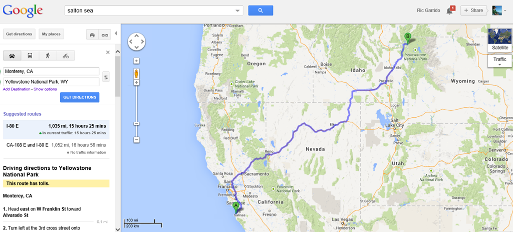
I do not want to travel this Interstate 80 route. I crossed Nevada last month.
The Longer Route on Less-Traveled Roads

Google Maps Alturas, California to Grand Teton via eastern Oregon and southern Idaho = 1,190 miles. An extra 155 miles to avoid Nevada.
Modoc County, California is the Wild West
The road less traveled will take me to a region of northeast California I have never passed through before. Modoc County is a vast region with few residents. There are fewer than 9,327 residents in Modoc County, California as the only people in an area 3,918 square miles, a California county larger than the area of the states of Delaware and Rhode Island combined. In fact, this high elevation desert is so sparsely populated that there are only 2.5 human residents for every square mile of the county. Few travelers pass through this part of California.
Alturas is the county seat and largest town in Modoc County with a population of about 2,800 residents. Alturas sits in the Goose Lake Valley at 4,370 feet.
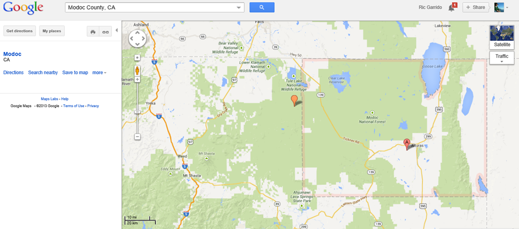
Modoc County in northeast California bordering Oregon and Nevada.
Burning Man and the oldest petroglyphs in the U.S.
Burning Man is the annual alternative lifestyle festival two weeks away over Labor Day in the Nevada desert in a remote location 120 miles from Alturas, California in Modoc County. The location of Burning man is midway between Alturas, CA and Reno, NV on rural backcountry roads. This is one of the most remote areas in the lower 48 states.
The location of the Burning Man festival in northwestern Nevada seems even more appropriate after recent findings date the oldest petroglyphs in the USA to about 13,500 to 15,000 years ago in nearby Pyramid Lake Indian Reservation of the Paiute tribe. There are fewer than 2,000 residents at Pyramid Lake. The petroglyphs in the reservation are 6,000 to 7,000 years older than the previously recognized oldest petroglyphs in Oregon.
California is a large state and Modoc County is a large chunk of land in probably the most remote part of California in the northeast corner of the state. This is part of the Great Basin region. While this area is one of the great bird migratory routes in the world for bird watching along the Pacific Flyway, Modoc County does not even bother with much tourism promotion. This place is truly for the birds.
Modoc Indian War 1872-1873
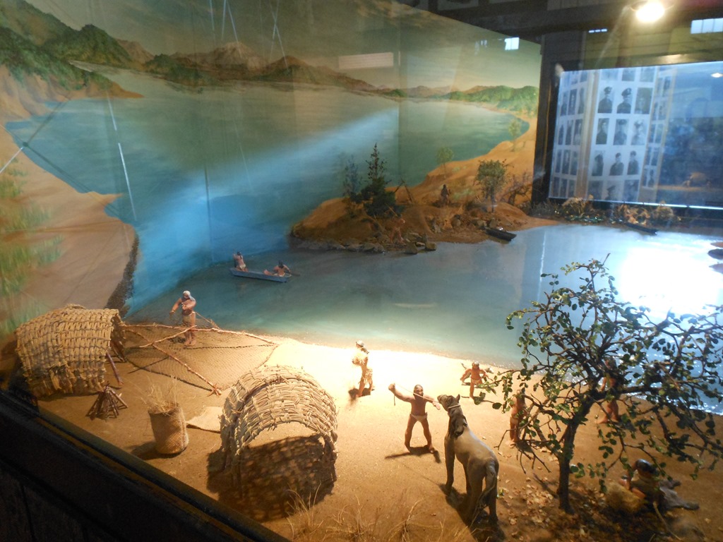
In summer 2012 I visited a museum in Klamath Falls, Oregon where I saw exhibits on the Modoc War of 1872 to 1873 and my life intersected with the Modoc tribal leader Kintpuash, more widely known as Captain Jack.
I enjoy the high school fair quality of exhibits in small museums. After reading about Modoc Indians for an hour today on the internet I learned far more detail of events from photos of the Modoc War exhibits I saw at Klamath County Museum for a $5 admission fee. I read recently that museums are the most trusted source of information by the public.
California’s Indian population was decimated in the 25 years following the Gold Rush of 1849. The Modoc War was the last of the Indian Wars in California where for two decades the state had a basic policy of Indian relocation and extermination. The Modoc War resulted in the death of General Edward Canby in 1873, the only U.S. Army General killed in action during the decades of Indian Wars in the American West.
Emigrants passed through the Modoc Indian tribal region in the 1840s as pioneers followed the southern Oregon Trail route as an alternative to the dangerous Columbia River route to reach the fertile Willamette Valley in Oregon. Conflicts between emigrants and U.S. Army soldiers with Modoc tribal people and other Great Basin and Cascade Range Indians led to emigrant pioneer petitions for the federal government to remove indigenous tribal peoples to Indian Reservations.

Forested hills and grasslands of northeastern California seen here in Siskiyou County south of Klamath Lake.
The Modoc tribal leaders signed the Klamath Lake treaty in October 1864 along with the Klamath Indians and a tribe of Snake River Indians ceding land to the federal government for a stipend with an agreement to relocate to Klamath Reservation in southern Oregon. The Modoc tribe had conflicts with the Klamath tribe and periodically backed out of their agreement and treaty to remain on the Klamath Reservation in Oregon. The Klamath tribe lived on their own homelands. In 1869 there were about 800 Klamath Indians, 350 Snake and 200 Modoc. The outnumbered Modoc tribe who had to relocate from their traditional grounds petitioned for their own California reservation. The federal government did not ratify the Klamath Lake treaty until February 1870. Boundary disputes with emigrant settlers reduced the land area for the reservation by the time it was ratified.
The U.S. Government would not authorize the Modoc tribe’s return to their own reservation on California. In April 1870 the Modoc leader Kintpuash, aka Captain Jack took around 155 members of his tribe off the Klamath Reservation and into the lava bed country of Modoc County, Siskiyou County and southern Oregon.
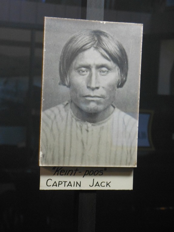
Keint-poos, Captain Jack photo in Klamath County Museum, Klamath Falls, Oregon.
California and Oregon farmers and ranchers petitioned the federal government to round up the Modoc Indians roaming the region. United States Army troops were sent to capture the Modoc renegades in late 1872 and return them to the Klamath Reservation. Soldiers were killed in in several battles of the Modoc War of 1873. Local residents also died in sporadic attacks. The U.S. Army suffered far higher casualties, about 82 soldiers to 17 Modoc Indian fighters.

1873 Modoc War Map in Klamath County Museum.
Captain Jack assassinated General Canby with a pistol shot during a peace negotiation April 11, 1873. The assassination of a military leader, U.S. Army commander of Pacific Northwest forces, sparked national outrage and prominent newspaper reporters traveled to Yreka, California to follow the action. Another Modoc leader, Boston Charley shot Reverend Eleazar Thomas.
General Jefferson C. Davis brought in more than 1,000 troops to combat the 50 Modoc fighters allied with Captain Jack. After successfully evading the Army troops for nearly two months, and with many of his fighters having surrendered, on June 1, 1873 Captain Jack surrendered. He was hanged, along with Boston Charley and two other Modoc warriors at Fort Klamath on October 3, 1873. The other 155 Modoc renegades who had left the reservation with Captain Jack were sent to Indian Territory in Oklahoma as prisoners. Today there are federally recognized Modoc tribes in California and Oklahoma.
The Sioux Wars of 1876-1877 included the Battle of the Little BigHorn where 270 men in the U.S. Army Seventh Cavalry including Lt. Col. George Armstrong Custer were killed. If not for this historic Native American victory in battle on June 25, 1876, the Modoc War and the name Captain Jack might be better known in the history of the Indian Wars.
Resources: Lava Beds National Monument – Modoc Homeland – National Park Service
The Modoc War 1872-1873, California State Military Museum
My Missed Counties of California
I thought Modoc County, California was the only county of 58 counties in California that I have never been inside the county boundaries. And it turns out that is not correct after spending 30 minutes today playing with Google Maps and checking all the counties in the Sierra Nevada mountain range. Turns out I also have never passed through one other county in California and ironically it is probably one of the most famous counties in California based on the Mark Twain story ‘The Celebrated Jumping Frog of Calaveras County’.
I have a feeling I will need to rectify that missed county of Calaveras in the next couple of weeks before embarking on my September road trip. It is about time I check out Angels Camp. Mark Twain claimed the jumping frog story is one he heard while staying at Angels Hotel in 1865. The 1850s hotel, no longer a hotel, is now a National Historic Landmark.
How can a Californian not visit one of the most celebrated California towns of the 19th century? And I will need to read that Mark Twain story too.
Ric Garrido, writer and owner of Loyalty Traveler, shares news and views on hotels, hotel loyalty programs and vacation destinations for frequent guests.
Follow Loyalty Traveler on Twitter and Facebook and RSS feed or subscribe to a daily email newsletter on the upper left side of this page.

8 Comments
Comments are closed.