Here are photos from Independence Pass Highway 82, Colorado about 20 miles from Aspen. We drove Highway 285 across the Rockies rather than I-70 traveling from Denver. This route is much prettier for mountain scenery in my opinion. The worst section of road is from Independence Pass to Aspen where the road was gravel for several miles and quite narrow.
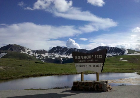
There are several hundred yards of paved paths at Independence Pass and a bathroom structure. Walking around the paths offers vantage points for taking photos of the numerous 13,000 and 14,000+ ft. peaks.

Poor Kelley stayed in the car feeling the effects of altitude sickness. I know how bad that can make you feel. Fortunately I didn’t suffer from altitude this summer like I did last summer when we stayed in Beaver Creek near Vail at 8,500 feet. The high altitude mountains invigorated me this trip.
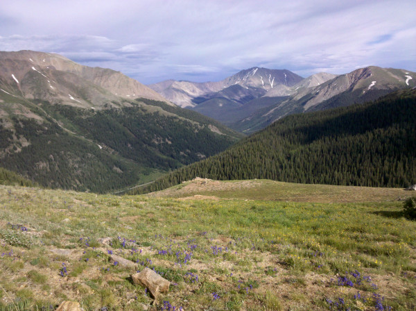
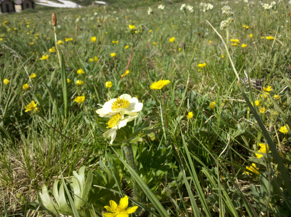
I read that this spot has one of the best views for seeing multiple high Rocky Mountain peaks. The wildflowers are intense colors at these elevations in the alpine tundra climate.
The weather in the Colorado Rockies  has been stormy for over a week. We hit one section Tuesday afternoon on Highway 285 when driving the flat high plains road just west of Jefferson where a menacing dark cloud opened up and suddenly dumped rain so hard that I couldn’t see anything when driving 60 mph. Nobody was behind me and I could slow down to about 20mph. No place to pull off the road and the water puddled so quickly I was hydroplaning. Fortunately I drove out of the rainstorm within one minute.
Aspen airport received over 1 inch of rain in 30 minutes on Monday evening. The Rio Grande paved bike trail from  Aspen to Glenwood Springs had several mudslides and one section was buried in up to 3 feet of mud.
Highway 82 over Independence Pass is definitely a road to be driven in good weather. My luck was good and the weather was pleasant at the pass with temperature around 60 degrees. What a relief after 100 degrees for the weekend in Denver!

The directions listed on these pictures are my best guess based on the direction of the sun in late afternoon. The mountain views are spectacular from this vantage point. The road between the Pass and Aspen is the worst part of the drive with several miles of narrow gravel road. I’m glad I was going downhill. Remarkably though, my car had the highest gas mileage ever on this drive.
My car likes the thin air and high altitude driving better than my wife.

Independence Pass Colorado wikipedia

Brokeass Mountain Road Trip, July 2011
Monterey, California – Denver, Colorado
- Yosemite’s Tioga Pass Road across the Sierra Nevada Mountains
- Westin Monache Resort Mammoth for year round vacations
- Even Lonelier than the Loneliest Road in America
- Earth’s Oldest Trees in Great Basin National Park Nevada
- Less extreme than 127 Hours in Utah
- Brokeass Mountain Tour eastbound – Hotel Value at High Elevation
- Brokeass Mountain Tour visits Starwood in Denver
- Driving by the 14ers South Park to Aspen, Colorado
- Top of the Rockies on the High Road to Aspen – Independence Pass 12,095 feet.
- St. Regis Aspen – Too Late to Cancel
- Aspen, Colorado to Park City, Utah: Ghost lands of Buffalo Soldiers, Utes and Dinosaurs
- The California Trail across Nevada
- Homeward Bound – Carson Pass Highway 88 over the Sierra Nevada to Monterey

5 Comments
Comments are closed.